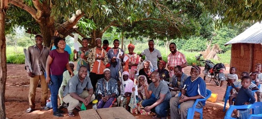
Recounting Ghana’s reconnaissance survey experience
Credit: Dr. Yaw Agyeman Boafo
The field team working on the Sentinel programme’s reconnaissance survey weathered wild and bumpy rides, up and down hilly landscapes, as they travelled to the six sites identified for the survey’s data collection from communities. The information collected was going to be analysed and written into reports that would later determine the two final sites to be selected for the main survey to take place in 2020.
The desk research, largely conducted using GIS images, first picked ten suitable sites across Ethiopia, Ghana and Zambia. In consultation with stakeholders and using other secondary data sources the ten sites were reduced to six. In Ghana, these were in the upper west, northern, western and Bono east regions.
The survey’s aim was to help establish the extent of agricultural expansion into natural habitats. The field team included socio-economic and biodiversity experts from the University of Ghana in Accra. Together, they visited the sites over a six-week period.
Each site had communities with individuals - mostly farmers - who were ready and willing to provide responses to our queries. This willingness to participate in the research was helped by the project team’s early visit to the site that sought to confirm the sites would be appropriate for the survey and to formally introduce the project to the local authorities.
The first tool administered on each site, a community-level focus group discussion, included several questions that solicited the views of respondents on a range of issues and sought to understand the nature and scope of agriculture in that area.
To keep the sessions interesting and energy levels high – important given the respondents were gathered together for a number of hours – there were ice-breaking sessions with singing, dancing and clapping, led by the community members.
The rapid environmental assessment/transect walk tools used to collect biodiversity data required the most physical exertion. The team, with the assistance of some community members, walked for several hours using identified transect routes. In addition to taking the walks, altitude and Global Position System (GPS) coordinates were also recorded. This enabled the team to obtain an overview of relationships between types of agricultural expansion, vegetation (natural and agricultural) and degradation (type and severity) as well as conservation or sustainable management practices.
In addition to the tools listed above, seven others were separately administered to women, the District and Municipal Assemblies, the Forestry Commission and other relevant stakeholders in communities.
The communities were very welcoming to the team during the survey and many expressed their desire for their sites to be selected for the main research.
Delali Kumapley is the communications and liaison officer on the Sentinel project, Ghana.
